TURTLE LAKE SHORELAND: Site Portfolio
1870s: General land office survey
The General Land Office survey done in the mid- 1870s characterized the varied landscapes across the county, documenting the land for future ownership. Descriptions of features were often site-specific. For instance, different points along the line transect that ran just south of the site were described as “tamarac swamp,” “rolling pine and hardwood country,” “cedar swamp.” Also things of economic significance such as timber stands or mineral deposits were often noted. The GLO survey map is located in the Knapsack section.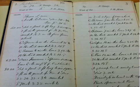 Photo of Marcell area (TWP 26W 59N) GLO land survey notes from 1875
1890-1900: Railroads bring logging
After the land surveys were complete, the logging industry begins to exploit the vast potential of red and white pine resources in northern forests, and creates plans for expansion of southern Minnesotan logging railroads into the north. The Itasca Lumber Company begins construction of rail lines north from Deer River/Grand Rapids area in late 1890s. Minneapolis & Rainy River Railway, or the “Gut and Liver Line” – as it was known because of the large quantities of sausage and liver served onboard – is incorporated by the Itasca Lumber Company to further streamline logging operations north. By 1901, they completed a spur from the “main line” to Turtle Lake, running through the present restoration site.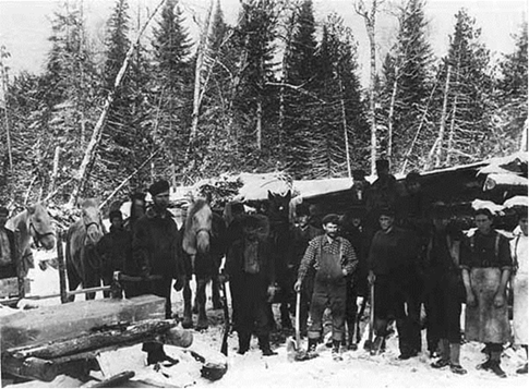 Lumberjacks in camp, Itasca County, ca. 1901
1920s-1930s: End of the logging era
The diminishing timber resources and the effects of the Great Depression slowed logging in the area. In 1932, as the Minneapolis Rainy River Railway filed a petition to cease operation, the first automobiles arrived in the Marcell area, signaling a sea change in economic activity and accessibility. As the timber boom died, the resorting industry surged. Fishing and lakes attracted vacationers to Marcell, and the town expanded to facilitate them, as camps and resorts popped up on area lakes. Some homesteaders tried their hand at agriculture, usually with scant results.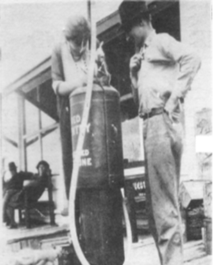 Marcell’s first gas pump, ca. mid 1920s
1940s-present: Mining and tourism
By 1940, the mining industry took interest in the region’s iron deposits, as resource demands for World War II grew. Even though most of the iron-ore mining would be established just east of Itasca County in St. Louis County, some mining operations did open near Marcell. The most notable was the Lind-Greenway mine near State Highway 38, the old route of the main line track of the Minneapolis & Rainy River Railway. By 1972, the Lind-Greenway mine had shutdown. Land impact can still be seen from Route 38. Marcell, post-1970s to present, has been characterized by the movement of local businesses in and out of the area. An ebb and flow of tourism has been maintained since its early years.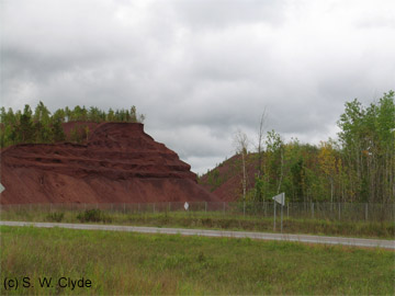 Lind-Greenway Mine est. 1941, closed 1972
1902-1910: Peak logging
With the timber industry cutting at a rapid pace and nearing peak lumber production, large tracts of land were being permitted for logging. A combination of women’s federation clubs, indigenous groups, and conservationists sought to minimize the effect of the industry on the remaining timber resources. These groups paved the way for the establishment of Chippewa National Forest in 1902. Yet the timber industry was still thriving, and in 1906, the Minneapolis and Rainy River Railway extended to Bigfork, north of Marcell. By this time, some area lakes, including Turtle Lake, had tracks out onto the lakes to allow trains to load logs more easily. In general, the main line railroad extension allowed the flow of goods and services to extend north to areas that had previously been difficult to access. This meant that more settlers were able to spread into northern reaches.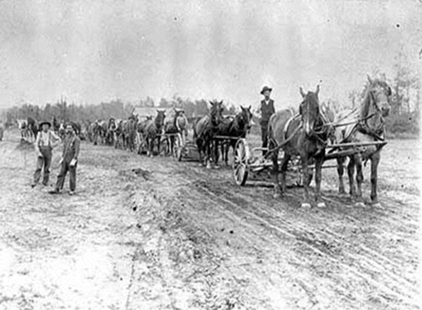 Extending the Minneapolis & Rainy River Railway north, 1905
Railroad Commissioner’s Map of Minnesota, 1908. Click on the markers to read more about the area’s history.